2010-07-23
Photos, Map1, Map2, Map3, Map4, Map5
Trip Report
| Col des
Etourneaux 273m, Colline du Fragne 457m,
Le Magnoux 501m, Puy de Montoncels
1287m, Pierre-sur-Haute 1634m 2010-07-23 Photos, Map1, Map2, Map3, Map4, Map5 Trip Report |
|
|||||
It was time for our annual holiday. This year on the program were – like last year – two weeks in the nice quiet and farely flat provençal town of Roussillon in the south of France. The vacation was beginning on Saturday, but for me it began already on Thursday night, because I had once again been selected for driving the car down while the rest of the family took the plane on Saturday morning. Because it is not a trivial drive (more or less 12 hours), I left two days earlier, spent the night in Paris at the in-law’s house and then took off on Friday morning with the slightly bigger Renault Velsatis of my father-in-law. Our own little Citroen had already been filled to the top with various completely unnecessary items, such as the kid’s photo album, which my dear wife wanted to continue during the vacation (and of course did not touch once in the two weeks), but also a couple of absolutely essential items, such as my bike. In Paris then two more items (the travel beds for the kids) were added and therefore we deemed it more practical for me to take the bigger car. Another reason was that we would be five people (3 adults, as Alexandra would also return with us, and two kids) ten days later, because we also planned to spend a couple of days with Elisa and Guillaume at her parent’s house in middle France. Voila
1. Col des Etrourneaux (HP Loiret)
I therefore left Paris at 6am on Friday morning, because it had a couple of
departmental high points planned for the day that were more or less conveniently
located “on the way.” After a couple of hours in rush-hour traffic suburban
Paris I eventually took A77 down to the Loiret department. The highpoint was
supposed to be located in the vicinity of the city of Châtillon sur Loire.
This information I had gathered from numerous websites and Google maps. But
while everything seemed to be so clear when sitting in front of the computer and
studying those maps, I now became fairly confused as to where exactly I had to
go. Apparently the high point had to be somewhere to the south of Châtillon
sur Loire and going down departmental highway D49. I eventually had to
turn right and then go another couple of kilometers to …… Well, yes to where?
The problem with these 300 meter highpoints is that they are not really very
prominent landmarks but rather often just small bumps or even worse the highest
point somewhere on a seemingly flat plateau. I just drove up and down highway
D49 looking for some obvious sign pointing to some obvious highpoint. And on my
second way up I noticed a sign saying “Les Etourneaux” (which was only visible
when going north, and therefore I had missed it on my early drive by passed the
intersection). Luckily I remembered now that on one of the sites I had seen a
reference to the “Col des Etourneaux”, which was indeed the highest point in the
department. Great, I thought, and took the small but still paved road west
believing myself to be a bit closer to my destination. And sure enough after
another couple of miles of driving on a gradually inclining road, I arrived at a
point, where I could no longer go up. This sounds more exciting than it really
was. It was not like I am arriving on top of Mount Everest, but a mere 273
above sea level. So what, you just have to take them when you get them. The
“summit” area was characterized by a couple of signs pointing out that yes,
indeed, now one has arrived at the summit. However, there was no reference to
it being the high point of the department, but I guess here I just have to trust
the internet (“once it is written on the internet, it must be true”.
2. Colline du Fragne or Terroir Randoin (HP Indre)
Off to the next summit. A more exciting one, because it would almost double the
elevation (457m, high point of the “Indre” department) I had reached on the
first one. But in spite of the higher elevation (and the theoretical more
clearly defined prominence) I had even more trouble finding it than the first
one. After the feeling of elation of conquering the first summit had worn off,
I drove south on highway D49 and numerous subsequent departmental highways for 2
hours. After about one hour I came through a larger town of Vierzon and another
30 minutes down the road through the town of Chateauroux. Driving down these
country roads was fun, as the landscape was very pretty (blooming sunflower
fields everywhere) and the weather was nice). Eventually I made it to the town
of Pouligny-Notre-Dame, according the to Peakbagger website and Google Maps the
nearest larger town or village to my destination. Peakbagger lists the
highpoint by the name of “Terroir Randoin”, but after leaving Pouligny-Notre-Dame
and going south for a little while longer (along highway D940) to the described
area I could not find any reference to that name. Instead I found almost hidden
in the tall grass a fairly new sign saying “Colline du Fragne”, very near the
location that was market on the map as the high point. I decided that it must
be here somewhere and turned on the dirt road, going up and down for some time
until I realized that I will not be able to get to the highpoint by driving, but
that I would have to get out and hike up the slopes in the nearby forest. The
map was of no use anymore, so I left everything and walked into the woods,
always following a general uphill direction. Pretty soon I was making my way
through man-high grass and ferns and already dreaded the own-body inspection in
the evening for ticks. But I ventured on, no idea whether I was close or still
far from the highpoint (and most of all no idea of how I should recognize the
high point. I reached some plateau-like area in the mids of trees, ferns and
thorny blackberries and walked around for 10 minutes or so looking for a marker
or some sign indicating the highpoint. It was a marker that I eventually
discovered under some fern. I had been close to giving up but fortunately found
it as I was turning around to go back to the car. Even though the summit was
only at 457m, I nevertheless was feeling elated (really this time) because it
had not been a trivial quest to find this high point. I took a couple of
pictures to remember forever this glorious moment and then turned to the
delicate but ultimately successful task of finding my way back through the brush
to my car. Two down, three to six more to go possibly. I could not be definite
at this point, because I had no idea how far I would get today. It was already
afternoon, but I had printed descriptions for another 6 mountains, just to be on
the safe side. Back in the car I returned to the main road, switched the radio
back on (I was listening to “A history of London” in 36 lectures (30 minutes
each) and programmed the GPS for my next destination, “Le Magnoux” or “Mont de
Saint Marun”, the high point f the “Cher” department and as an extra benefit
also the highpoint of a French region, of which there are only 22.)
3. Le Magnoux or Mont de Saint Marun (HP Cher)
Le Magnoux is at once the name of the highpoint and the name of the nearby
hamlet at whose outskirts the actual highpoint can be found (actually that
hamlet is part of a larger community of “Preveranges”. At 501meter it is higher
than the two highpoints I had visited so far on that day, but the approach is
rather boring. One can drive right up to it, as the whole village is on a high
plateau. The highpoint is marked by a nice big sign which states that this is
the “point culminant du Cher and de la region Centre”. Nearby is a water
tower. Looking around I had nice views to the south numerous villages on other
high points or mountains, some of them definitely located higher up, but likely
in another department and region. Behind the water tower about 80 meters from
the main road was a half moon shaped viewing platform, which pointed out nearby
as well as far away summits (Mount Ventoux, for once). Back at the first sign I
realized that the elevation here was given as 504 meters. Hmm, a discrepancy of
3 meters with what I had researched online. What to do? Nothing at the moment,
but I told myself that I would research that once I got back home in front of
the computer. At the time of writing this, I am not any smarter than before
having found contradicting information online.
4. Puy de Montoncel (HP Allier)
The weather was still terrific and I enjoyed myself immensely. I had not yet
eaten, but wanted to hit one more high point before taking care of food. I
chose the high point of “Puy de Montocel”, at 1287 meters higher than the
combined elevation of the three summits I had reached up to this point. I got
back in the car and after a quick visit of one of the villages to the south that
I had made out from the summit I was on my way east before going south towards
Clermont-Ferrand and then east again along highway A72. Once going east on A72
I noticed heavy grey rain clouds coming my way, and sure enough, about 10kms
before I had to leave the interstate I got drenched (so to speak). It was a
fairly big storm that also produced a lot of hail. I decided to drive past
Palladuc, to sort of get behind the storm and then try to find a way up from
there that would get me to the trailhead. Actually I had no idea whether there
would be a trailhead, but I planned to drive up on paved roads (and dirt roads
if necessary) as far as possible and then continue on food. I thus turned left
at Chabreloche and headed north up a variety of narrow roads. It was still
raining a lot, but once I had gone through the little hamlet of Les Cros (and
the “Auberge du Montocel” and left the paved roads, the sun came out again and
the weather almost instantly turned nice again. Shortly afterwards, when I
parked my car, there were very few clouds left in the sky, but the trees were
still glistening and dripping a lot and when I started walking I was glad that I
had brought a rain jacket because I was getting dripped on every time I walked
underneath a tree or touched a bush. I followed the forest roads in an uphill
direction towards where I though the high point must be located. After a while
at an intersection I followed the same strategy turning right and uphill. At
some point the forest road went downhill again, and because according to the
rough map I had brought I believed to be close to the high point I left the road
and went cross-country further uphill. I have no idea whether I reached the
summit as I never found any marker or other obvious sign but I did reach a
plateau-like area in a clearing where numerous hints could be found that at
least some other people had come to this point (and why would they otherwise?).
There was an empty bottle put upside down on a stick, and there were a few more
non-natural sticks that had been put here for some reason. A lot of trees had
been cut down by a chainsaw and maybe there was a marker somewhere there but I
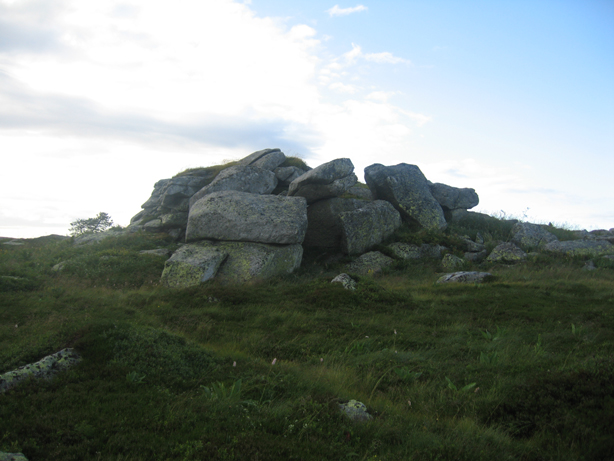
did not find it. Nearby was moss-covered pile of rocks, and because it was a
bit of a prominent point I declared it to the summit of the Puy du Montocel. I
climbed it and took a few pictures and was then on my way again retracing my
steps back to the car (which took a mere 15 minutes). The summit, had I then
reached it, was a nice little exercise in routefinding, but because of the
uncertainty whether I had indeed reached, I drove a way with a mixed feeling.
Again, if I were ever to come to this area again, I promised myself to do a bit
more research beforehand and climb the peak again some day.
5. Pierre-sur-Haute (HP Loire)
It was already almost 6pm when I drove away from the Puy du Montocel. What to
do next. I quickly studies the possibilities and I picked as my next target
“Pierre-sur-Haute”, the highpoint of the Loire department. This was not only
the nearest one to where I was at, but it was also on my way, so to speak, or at
least not too far out of the way. Plus, I could spend the night somewhere in
the Ardeche or Lozere area and maybe do a couple of more summits the next day.
Therefore, I floored the gas pedal and after a quick stop at the grocery store
and the gas station, because I was getting a bit hungry after four summits and
had been doing already many of hundreds or kilometers today, I drove the 50
minutes hours to the town of Chalmacel. This was the closest town to the summit
and from there I set the GPS to the city of Puy where I planned to spend the
night and along the way I would drive on the D6 over the “Col du
Béal” from where the highpoint was only a mere 2.5 kilometers away.
Apparently, at least that was how I interpreted the map, I would be able to
drive pretty much all the way to the summit (where some sort of military
installation or antennas occupied a large area). However, when at about 7.30 I
arrived at the pass, I immediately saw a big Do Not Enter sign, but there was no
barrier. I briefly contemplated whether I should risk driving the car up in
spite of the sign, but then remembered that it was my in-law’s car and that I am
a little bit overcareful when it comes to the military and therefore decided
against it. But then I remembered my bike, stashed way deep down in the trunk
under a bunch of other luggage. I quickly got it out and assembled it. It was
getting quite cold and windy. Dark clouds flew by at a rapid pace and the sun
which would not set for another 90 minutes or so still illuminated the landscape
quite nicely. But it was cold nevertheless and I quickly put on a extra layer
of clothing before swinging on my bike. I rode pass the “do not enter” sign
assuming that bicycles would be exempt from that command. The pass was at 1400m
and I therefore had to gain some 300+ meters to the summit. No problem you may
think, but the headwind was very strong and cold and I therefore inched my way
up the paved road only slowly. Coming back down would be more fun. Still it
only took me 20 minutes to make my way up to a closed gate from where I could
see the fairly extensive military installations on the summit. No way I was
getting in there. I briefly considered climbing the fence, but I saw one car
parked out front, which meant that the station must be manned. I rode back down
the road for a few meters before dragging my bike off to the side and laying it
into the grass. There was an outcropping of rock with an iron cross 100 meters
or so to the west of the road and I hiked up there. Walking through the tall
grass I got my feet soaking wet but did not care. The thrill of having reached
my fifth French departmental highpoint in one day covered for that little
inconvenience. I stayed on this make-do summit for 10 minutes contemplating the
solitude and the nice scenery surrounding me (which was visible more or less in
spite of the pretty dense and low hanging clouds). All the time I was also
wondering whether there may be someone watching me from the military buildings.
Upons this note of paranoia, I walked back to the bike and rode back the paved
road to my car. I still had a couple of hours of driving to do. I put my bike
back in the trunk and wanted to take off, when I decided to give the nearby
“gite” a chance. There were a couple of cars parked up front and I could see
through the window that a couple of people were having dinner. It was getting
dark already and I had to drive during the dark anyway and so I decided to also
have dinner at the place (support the local economy, because business was
obviously slow that night). A pretty young couple was running the place and
they were very friendly. The guy explained the menu to me and I chose the
“cheese and sausage platter”. I forgot the exact expression but I was served a
variety of cheeses and “jambons” alongside with “cornichons” and bread. It was
delicious, the only thing missing was a beer. But I opted for limed flavored
soda water instead. Actually I had three of those, also very good. The couple
was very interested in talking to the tourist and particularly the guy wanted to
practice his English. I complied to that request telling him about what I was
doing, what I had done and where I was headed. I also mentioned that I had yet
to find a place and five minutes later he came back with a print out of all the
hotels in Puy, including phone numbers, and he also let me use their land line
phone. I was overwhelmed. Too friendly. I had briefly considering staying at
the gite (they had about 10 beds available), but I did not want to have to do
the two hours early in the morning and there called a couple of places before
reserving a room at the second or third place I called. Apparently, there was
some festivity going on in Puy and in retrospect it was probably good that I
called and reserved in advance instead of just showing up at various hotels,
because there were only a few rooms left. Great, great, great, I love it when
things work out perfectly. After paying I got in the car, put back in my book
on tape and drove the remaining 100km (but two hours because of switch-backs,
etc.) to Puy-en-Velay, where I arrived at around 11 or so and immediately check
into the hotel and went to bed.
More Mountain Stuff: Back to Overview.
This page was last updated: Feb 02, 2011