2005-11-06
Photos
Map/Profile
Trip Report
|
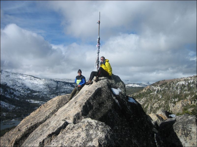
Flagpole Peak- 8,363 ft,
EchoPeak- 8,695 ft,
Angora Peak- 8,588 ft,
Keith's Peak- 8,646 ft
2005-11-06 Photos Map/Profile Trip Report |
|
|||||
We started hiking at around a quarter to 9 and already left the trail after about 200 yards to head east up to the ridge leading to the summit of Flagpole Peak, the first destination of the day. Following the ridge line was straightforward and it involved some fun scrambling. Only one narrow ridge traverse with snow on one side and a drop-off on the other was a little hairy. But we managed all right and stood on the summit shortly after one hour into the hike. There is indeed a flagpole on the peak with all sorts of garments or pieces of fabric tied to it. Interestingly, next to the pole, we found an urn with ashes. No name or other hints pointed at the identity of the deceased, but we reasoned that it must have been a fan of Lake Tahoe and the Desolation Wilderness, because the views of either are very nice from this point.
Richard H thought about turning back at this point, but we managed to convince him to continue on to Echo Peak, whose high point was already clearly visible and only a short distance away. Turning back now would also have involved hiking back down the class 2-3 sections that we had just come up and I knew that beyond Echo Peak a wide plateau and a class 1 trail would lead back down to the lakes in a safer manner.
We followed the obvious way up to Echo Peak encountering more and more snow along the way and arrived on the summit about another hour after we had left Echo Peak. Spectacular views of Lake Tahoe and Fallen Leaf Lake from the summit. Unfortunately, it was very overcast and the sun only peaked through the clouds on occasion. We nevertheless took plenty of pictures. Pyramid Peak and Jack’s and Dick’s were covered by clouds almost the entire time. After 15 minutes on the summit we sent Richard H on his way back down to the lake and Richard S and I continued on to the peak that obstructed the view of the whole Fallen Leaf Lakes. It was Angora Peak, located between Fallen Leaf Lake and Echo Peak, and probably not often visited, because it is not on the beaten track. The traverse over to that peak involved some tricky class 3 scrambling on bad and wet rock. Furthermore it involved a descend down to a saddle between Echo Peak and Angora over fairly big boulders and lots of snow (this was the east slope now). It was fairly slippery and it was difficult to estimate whether the spaces between two rocks were filled with smaller rocks or only with snow. So it involved some potholing, but after passing the saddle, the western slope of Angora Peak had less snow on it and after scrambling up that slope (and experiencing the obligatory false summit), we arrived on the summit of Angora Peak.
We stayed for a while on the summit before heading back the way we came to the large plateau of Echo Peak. At this point I already knew that we would probably not have enough time to reach Ralston Peak on the other side of the Echo Lakes Valley and Richard and I agreed on scaling the summit of Kieth’s Dome first before re-evaluating the situation. But the clouds were now moving in fast and pretty soon Ralston summit was not even visible anymore. We tracked down the western slopes of Echo Peak, now encountering a lot of snow in the trees on this side of the mountain. We kept looking out for Richard H’s tracks but never saw anything bigger than foot prints that we thought must belong to a mountain lion (an on line search later confirmed the close resemblance although it could have been any type of cat, I suppose, do they have cougars up there?).
After another 45 minutes and some potholing (although the snow mostly supported our weight) we arrived on the summit of Kieth’s Dome, which was really just a high point and did not involve any exciting scramble or anything similar but just a gradual hike up. We spent little time on the summit and after finally abandoning the original plans of now hiking up to Ralston (now completely covered by clouds), Becker and Talking Mountain, we hiked straight southeast to eventually hit the Pacific Crest Trail which, 3 miles and about one hour later, led us back to the trailhead, where Richard was waiting. Along the hike back we only met only two other hikers but passed many log cabins along the Echo Lakes, most of which were not inhabited throughout the winter. We wondered about the prices for the houses and on the way home, Richard H. informed us about his plans of making one of these cabins his retirement home (clearly delusional at this point, the poor fellow). It was also his “homework” to investigate housing costs in the general area, but so far I have not heard anything yet, so it was probably reflective of the costs of housing in and around Lake Tahoe and therefore not affordable at all).
A quick stop for French fries in Placerville and the delicious chili at Richard S’s house finished another perfectly fine hiking day. (oh yeah, and the Kings beat Phoenix in an exciting game by two points).
More Mountain Stuff: Back to Overview.
This page was last updated: May 24, 2008