2005-10-09
Photos
Map/Profile
Trip Report
|
Desolation Wilderness
("Mount Tina", Mount Agassiz, Mount Price, Jack's Peak, Dick's Peak, Mount
Tallac) 2005-10-09 Photos Map/Profile Trip Report |
|
|||||
Fun trip yesterday.
For some time now I have been toying with the idea to start with two groups on opposite and to hike one way instead of looping back to the trailhead. Of course such a trip should be planned perfectly so that the two groups do not have problems meeting to exchange the keys to each other vehicles (and therefore the ride home).
Rich and Tina were agreeing to this approach
and it was also the only way that we could do what we wanted to do. We planned
a hike through the Desolation Wilderness. The Sexton party had been on a
reconnaissance hike into the Crystal Range out of Wright’s Lake a couple of
weeks ago and therefore were not opposed to the idea of starting at the Glen
Alpine trailhead out of Fallen Leaf Lake, even though this would involve another
45 minutes of driving. (We could have car shuffled and then gone as a group
from one car to the next, but that would have cost us at least 90 minutes of
driving and we therefore decided to try the key-swap exchange.) Rich and Tina
therefore had already been to Mount Price and Mount Agassiz (and to a unnamed
peak that they christened Mount Tina) and therefore were more interested in
climbing Dick’s and Jack’s Peak. I had seen Price and Agassiz from my hike to
Pyramid Peak earlier in the year and therefore was keen on completing the
Crystal Range.
I arrived at the Wright Lake’s trailhead for Twin and Grouse Lakes at shortly
before 7am and after packing my stuff I headed out at 7:05. It was a beautiful
morning, the freezing morning air was pretty crisp and due to the absence of any
wind it was completely quiet. Despite more than 10 cars in the parking lot I
did not see anybody for the next ten hours except for two campers right after I
started hiking and Rich and Tina for the key exchange. At around 8 am I arrived
at the small lake east of Grouse Lake were I saw what according to my map was
beginning of the ridge leading up to Mount Tina and then eventually to the
plateau in between Price and Agassiz. I scrambled to the top and then spent 45
minutes following the ridgeline upwards (I also tried to stay at the highest
point, except when it became too much of a class4 climb). I summit Tina at 8:45
or so and then headed over to the plateau in between my next to destination. I
hesitated for a moment, because I could not see from the map exactly, which one
I should do first in order to end up closer to where I though I could easily
drop down to Mosquito Pass and the Desolation Valley. I decided for the right
one, which turned out to be Agassiz (9967 feet) and the right decision. Agassiz
sort of looks like a sail flag and was therefore an interesting class 3 climb to
the summit, although on solid large slabs. I next headed over to Price, which
was an easy hike up to its 9975 feet. While on Price, I peaked over to the edge
looking for an easy way down. Most of what was visible was sheer drop-off,
although a little further north from the summit, it looked like a fairly easier
class 3 with maybe a few more difficult moves down. That was the way I took and
after maybe another 45 minutes or so I found myself near Mosquito Pass and the
Rubicon Trail that was leading across it. I was too lazy to hike down to Lake
Aloha for water and just refilled at a puddle. The water was probably not as
good as the lake water, but nothing that could not be cured with two iodine
tablets.
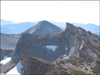
I had tried to reach Richard and Tina on the radio at the agreed time of 10 and now at 11, but I had not gotten a response. I had no idea what happened, but according to my calculations I should be running into them soon. From Mosquito Pass I looked up to Jack’s Peak and saw really two ways up (or down), which were not visible from each other. Therefore I contemplated for half an hour what to do (hoping that I would see them in the meantime and the problem would take care off itself). I eventually decided to head up the easier looking south side of the mountain leading to its long ridge (which eventually leads to the summit). The cell phone had worked on the summit of Price and when I tried it again I got through to Catherine and Terri S. I told them that I would in any case go to the Alpine Glen TH (Rich had given me a spare key, but I still had the one that he was supposed to get). If we would not meet I supposed, Rich and Tina would likely go back there. However, as soon as I reached the ridge and could actually see the summit of Jack’s, I saw two figures on it and it dawned on me that my panicking had been too early. Upon arriving at the summit and talking with Rich and Tina, I learned that they were able to hear me the entire time on the radio, but that a defect on theirs or mine did not enable us to get in contact. Well, that did not matter now as I gave them the key and went on my way over to Dick’s Peak, which at 9974 feet was slightly higher than Jacks at 9856 feet. The two peaks are only a little more than half a mile apart, but the traverse involves dropping a bit over some class 3 terrain before heading back up to Dicks. On the summit of Dicks I for the first time today found something that resembled a summit registry. I was an empty water bottle with lot’s of lose paper in it, but without a pen. I wedged it back under a couple of rocks and tried to remind myself for the future that I should always bring a spare notebook and pen (however, I never follow that advice therefore always get stuck in situations like these).
The way down from Dicks was straightforward as a use trail was clearly visible. I followed it until it intersected with the PCT, which I followed up a while to Dick’s Pass. From the summit of Dicks I had seen Mount Tallac in the distance a good 2 miles away (as the bird would fly). It looked like a traverse over there would be possible without much elevation loss and therefore I headed straight east from Dick’s Pass through spare trees and passed smaller peaks and ridges. At some point half way along the traverse I realized that I could not keep this high as the hiking turned into hiking which became too difficult. I therefore decided to drop down a little towards Gilmore Lake before reaching the ridge that lead up to Tallac. I descended a steep bolder slope and then bushwhacked through some dried up brush and across a couple of meadows before hitting unexpectedly on a trail leading up seemingly to Tallac. I knew that it could not be the Tallac Trail that leads up from Cathedral Lake as I had been on that a couple of times. When studying the topo maps a little bit more thoroughly, I realized that one can climb Tallac as an alternative from the Alpine Glen Trailhead. However, from this point on the going was tough. I advanced slowly and actually got passed by a young couple, which probably wondered about the slow hiker.
It took me about 45 minutes for that last mile, but at 4pm I reached the summit of Mount Tallac, where only about twenty other people were already assembled to celebrate their like success. I did not stay long, because I did not want Rich and Tina to have to wait too long because of my spontaneous and unannounced excursion. So I just took a few summit shots and left. The way down seem to go on forever, but eventually I reached Rich’s car at a little after 6.
We had arranged to meet in Placerville for supper where I arrived at 8 o’clock (traffic was a little bad up to Echo Summit) but ok from there on) and was glad to learn that Rich and Tina were only 20 minutes behind me. Perfect timing.
More Mountain Stuff: Back to Overview.
This page was last updated: May 24, 2008