2006-01-29
Photos
Map/Profile Map/Profile Map/Profile
Trip Report
| Mount Diablo - 3849 ft
(1173 m),
Mount Tamalpais 2571 ft (784 m), Mt Burdell 1558 ft 2006-01-29 Photos Map/Profile Map/Profile Map/Profile Trip Report |
|
|||||
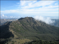
A fun outing. I had to drop of Catherine at
the airport and on the way back (it was only 6 am) I spontaneously drove right
passed Davis to the foot of Mount Diablo on Regency Drive in Clayton. I left the
car at 7:20am, got to the summit at 9 and back to the car by 10:30. I only
saw one other hiker on my way down. The views from the top were quite nice, not
many clouds and the snow covered Sierra was looming in the distance. Looking
west, I could see Golden Gate, Mount Tamalpais and Mount Saint Helena at the end
of the Napa Valley.
On my way back I sat in traffic for a while on I-80 and decided to take a short
cut through Napa and then Berryessa back to Davis. However, I suddenly
remembered Mount Tam and used the congestion on the interstates as my excuse to
climb another mountain. I got to the base of it (close to the water tower of
highway 1) at around 1:30 and was up and down by 2pm. Now I really wanted to go
home and drove up 101 to take 37 back east. But shortly before the exit off 101
I saw another hill just five minutes of driving beyond that point. I got to the
town of Novato, parked my car and walked up (running up was not possible
anymore). I got to the top I don't know when and reached what I thought to be
the high point (pretty undefined, because the summit was mostly flat and covered
with trees).
More Mountain Stuff: Back to Overview.
This page was last updated: March 3, 2010