2005-09-10
Photos
Map/Profile
Trip Report
|
Mount Morrison- 12,268 ft (3,739 m)
2005-09-10 Photos Map/Profile Trip Report |
|
|||||
The second day of Janni’s and mine epic hiking trip. Yesterday had not been too tough and we also expected today to be pretty straightforward (little did we know that it actually would become a major undertaking). The guidebook on “Climbing California Mountains”, which was my only real reference, listed the hike as a moderate outing, consisting of only 9 miles roundtrip and most of that on trail.
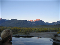
With that knowledge and due to the fact that we had camped close to the hot springs, we slacked off in the morning and did not get to the trailhead before 8:30 (even though the trailhead is located pretty much opposite of the hotsprings (opposite of CA-395) near Convict Lake). After getting up before 6 am we soaked in the hot springs and saw how the rising sun behind us slowly illuminated our objects of desire (at this point I was still thinking about bagging Mount Laurel too) and eventually us. We had delicious oatmeal with a bunch of very “al dente” fruit cut into it for breakfast, which we also consumed in the hot tub (great invention these hot tubs, did I mention that?).
After arriving at the trailhead we quickly set out on the trail and past Convict Lake on out left. A very cold wind was blowing down the valley and I was glad that I had brought my wind breaker. Janni was well equipped as well with several layers of clothing and even long pants. The impressive east face of Laurel came into view and I began looking for a way up it (apparently a class 3 route exists, but it involves intense route finding). We followed the trail further up the canyon and it almost stayed within site of Convict Creek. Eventually we came to a spot where a bridge was supposed to lead across the stream. However, only fragments of concrete were left as the only evidence that a bridge had existed here and a couple logs served as a new bridge. I am not sure what spring flood, or avalanche or rock slide had come through here and when, but it sure must have been very powerful. A couple hundred feet further another or the same catastrophic event had wiped out the trail (remaining was a deep gully or chute, where the trail should have been), and a use trail lead around that obstacle. According to the guide book, we now had to turn left and climb up the rock face in front of us. Apparently it was only a mile or so from this point to the top. I lead the way and quickly gained the first immediate rock wall, which included a couple of class 3-4 scrambling moves. They probably could have been avoided by walking further to the right, but everything else looked at least class 3. Actually from this point on we pretty much stayed in class 3 territory. Up on the first ledge I waited for Janni and continued up the lose scree on Morrison’s west side as soon as I saw him coming into sight. Up and up we went until we finally saw what we thought was the summit, only to notice when we had actually gotten to that point that we were only half way there. The next half an hour however, we spent scrambling up some granite face, which was more pleasant than the loose scree, because it was much easier walking up that giant slab of rock.
If I would have done a little bit more research, I would have realized that there are actually two summits on Morrison (the north and the south summit) and I would have wasted no time climbing what turned out to be just some rock ridge on the saddle in-between the two higher points. The climbing was fun, but definitely class 4 and not something that I would have done all alone on the mountain. I arrived on the top of the ridge and realized that there was one point in the north and another one in the south higher than me. Well, that was just great. As I said, with a little bit of research all the upcoming troubles could have been avoided, but of course as always when there is a 50 percent chance for being right, I chose the other 50 percent. In this case I aimed at the south summit, which from where I was looked higher than the north summit. From the top ridge I tried to yell and signal Jan that he should move over to the south as well, but it was too windy and he did not hear. Therefore I followed the ridge, from which I eventually climbed down, until I got into more solid class 2 territory already half way to the south summit. From here I turned around and went back until I reached Janni and told him about my plans. He was game and I lead the way again towards the south summit. Getting closer I wondered about the easiest way up, since it consists of some sort of steep summit rock pile. A use trail appeared to be leading to the west part of the pile (another apparent proof that this was the right summit), but I stuck to the north face of that pile, where I saw a straightforward rock gully, which I assumed would lead to the top. I scrambled up it and got to the highest point only to realize that the actual summit was 30 yards further south. However, I easily reached it after a short scramble along the ridge. Fantastic views from this summit of Baldwin, Bloody, Laurel, Lakes Genevieves and Edith, and Banner and Ritter in the distance. However, I did not see a summit registry and I distinctly remembered having read about one. And then it dawned on me that the north summit must be the real high point. Shit, I thought, how am I going to tell that to Janni. Where was Janni anyway? I hiked back to the top of the chute, but could not see anyone. I hiked down another way and made it back to the bottom of the chute just to see Janni sitting higher up at a point just before a real steep section of the chute. He came down and heard about my abysmal route finding and leader qualities. Janni hesitated only briefly when I suggested to hike over to the real summit. That hike over would not involve much in elevation loss or gain and it would possibly only mean another 400 yards of walking along the ridge of the saddle.
We reached the summit at around 3 pm and spent a good half an hour taking pictures of ….. and relaxing. We signed the summit registry and hiked down to an some sort of platform to take a photo of the entire Convict Lake (only half of it was visible from the summit). It was still very windy and we went over to the east side of the summit to get some protection of the fierce wind around us.
We went down the same way we came up, which was actually very enjoyable, because the loose scree enabled us to heel/slide down quite quickly. Eventually we reached the trail again and met three more hikers coming down Convict canyon from what looked like multiple day hiking trip. It was already passed 6 now and I started regretting that I did not bring my real glasses. I was wearing my prescription sunglasses and had left my real glasses at home assuming that we would easily be back before night fall. Now it looked like that would not happen and indeed, when we got back to the car a little over an hour later, it was pitch black (at least for me with my sunglasses).
All in all an exciting trip. The bad thing, however, is that I discovered at least 5 more mountains that I want to climb in that area. So many mountains and so little time.
More Mountain Stuff: Back to Overview.
This page was last updated: March 4, 2010