This one had been on my mind for a long
time, ever since my dismal route finding abilities lead us up the wrong ridge
(see last June's outing for specifics).
Sure, we did climb Houghton, Relay, and Tamarack on that occasion, but we never
even got close to Mount Rose. Today's trip, however, turned out much more
successful because the weather was perfect (not that I want to blame the
overcast skies last June). Considering the fact that last year's trip was almost
two months later and there was still a ton of snow on the ground, you get an
idea about the amount of snow I had to deal with today.
Because of the snow, I was not able to find the dirt road that composes the
first half of the Mount Rose Summit Trail. Worse still, I was not even
able to find the little maintenance shed that we parked next to last time.
Therefore I parked on top of the summit of CA-431 from where Mount Rose was
clearly visible. I put on the snowshoes as soon as I stepped onto the
snow. At 8:15, I left relatively late and the snow was already very soft.
Over the next 90 minutes, I worked my way cross-country to get to the spot where
last time we had mistakenly left the trail. That spot had been in plain sight as
soon as I had begun hiking, but because of minor ridges and chute it still took
me that long to arrive at that point. This was again proof that one can never be
prepared enough for such a trip. Although I had studied the topo maps of
the area, I had mainly concentrated on finding the right way up the mountain
from this point on and not so much on how to get to the point. If I would
have known about all the ups and downs and the very soft snow I would have taken
the access road and probably arrive in less than 90 minutes even though it is a
longer approach.
In any case, I continued up the fairly steep ridge and then worked my way up the
chute to get to the saddle between Mount Rose and its close neighbor, Church
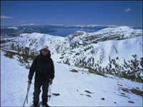
Peak. I climbed Church Peak first and then got to the summit of Mount Rose
at around 11am, where I took my obligatory panoramic shot. It was very warm and
I could have easily hiked down in shorts and t-shirt, but I did not take of
anything, because of yet another blunder, the fact that I had forgotten my
gaiters. In order to prevent too much snow from entering (and drenching) my
boots I kept my pants on and left the summit. About half way down the
mountain I met another hiker on his way up. We exchanged a couple of words, and
he kindly took my picture.
I headed straight down the major chutes knowing that eventually I would hit
CA-431. Again if I would have studied the Topo maps more thoroughly, I would
headed in a more westerly direction, because when I got to the road I had to
slog back up to the summit (and my car) for a good 2 miles. But all the
negativity aside, it was still a fun trip and also just a warm up trip for
bigger things to come tomorrow. I drove to Reno, turned South onto 395 and
then drove straight for 4 hours before stoping in Independence to get something
to eat (Subway) and to admire the fantastic snow-covered Sierra Nevada.
More Mountain Stuff: Back to Overview.
This page was last updated: May 20, 2008