Yippie, le Mount Ventoux en velo. The Mount Ventoux by bike. We had chosen this destination, for three reasons. First, it was the destinationo of the second to last day of this year's Tour de France, and we absolutely wanted to do what Lance and co were doing. Second, it was the nearest major summit from Roussillon, where we were renting a house for two weeks, and pretty much visible from everywhere. And the third reason was that one has to do the Mont Ventoux
is an almost legendary destination for any biker, not alone because of its dominance of the surrounding landscape and the nice long descend one would have at the end of the day, but also because of its last six kilometers which offered on average a 12 percent incline, but in place there were short ramps of up to 17 percent.
Needless, to say we would not be the only ones on the summit, for on a typical summer day over 2000 bikers attain the lofty summmit. But first of all we had to get to the summit.
Over the past 10 days, Bernard, Catherine's father, and I had done a few practice runs in the nearby hills, but never doing more than 90km in one outing. But we still thought we were prepared to take a crack at the Ventoux. We had also
spend quite some time brooding over the maps trying to find the shortest way and the most efficient in terms of elevation less and gain to get to the mountain.
We finally decided to come in from the east throught the town of Sault. In order to get there we would have to go from an elevation of 250 meters where our house was located over a pass of nearly 800 meters in the Javon Forest, down to Sault which can be found at an elevation of 500 something meters. Sault would be a bit more than half point. However, from Sault we would only have to go uphill for 26km up to an elevation of 1905 meters. Later we learned that many bikers actually drive there cars to Sault, park there, have breakfast or lunch and then starting riding up the mountain, which of course at the time we thought was some kind of cheating, but which in retrospect seemed like a good idea.
In any case, we set out at 6:30am from Roussillon for the town of Saint Saturnin les Apts, where we left the busier roads for a smaller, very scenic road that led through the Javon Forest and passed the impressive Javon Castle up to the high pass of the forest, before dropping to the town of Sault.
In Sault we stopped for a few minutes to have a refreshment and buy some bars for the rest of the day.
By now, about 9:30 in the morning, it was already getting pretty hot and over the next 20km, for which we needed a bit less than two hours
and which got us to the Chalet Reynard, I was sweating profusely, even though I was only moving at the dismal speed of 10km/h. I was always aiming at the kilometer markers (bornes) that are placed along most French highways and that
also on this route gave me an indication of where I was and how much more I had to go.
The incline was very tough on the first 10kms where we went from about 600 meters to 1100 meters, but less steep (even though still steep enough) during the last 10km, where we went from 1100 meters to 1400 meters at the Chalet Reynard.
Even though I was disadvantaged technologically, for my cross road/mountain bike was much heavier than Bernard's road bike, I had the advantage today, because of the 21 gears I could choose from compared to his 16 (or 14?). He would be faster on the descend (even without pedalling), but uphill I was quicker and therefore always before him. I stopped every 5km or so for him to catch up, meanwhile having dozens of bikers pass me on their own way up to the summit.
At the Chalet Reynard we took a 15 minutes cold beverage break. While we were sitting in the shadow, there were lots of bikers going up the mountain and coming down, because another road up the mountain merges with the road we were on at this point).
It was also here at the Chaley Reynard were the remnants of the Tour de France were still visible. The entire pavement for the last 6km to the summit was full of cheers for individual contestants in the race, such as Go Lance, or Go Andy or similar. Unfortunately, I could not see any Go Henrich, because I really could have needed it. With 60 km already in my legs, I was getting tired despite the meal we just had. It did not help that the remaining 6 km were the steepest part of the whole day. The summit structures were visible the whole time, and we had the impression that it was just a few hundred meters (probably would have been on foot cross country), but the switchback would leads us closer but then again farther away from the summit, seemingly.
It did not help that also here the kilometer markers helped us gauge the remaining distance, because in addition to having 1,2,3,4,5,6 written on them, they also informed us about the steepness of the section ahead. I believe the first one said something like 11 percent over the next 1.5 km, and those 1500 meters were a killer. Imagine my joy then, when the third marker said: 13.5 percent incline of the next 3km. Hurray. At some point, I could not stand it any more and got off my bike to finish my water bottle and pause for a
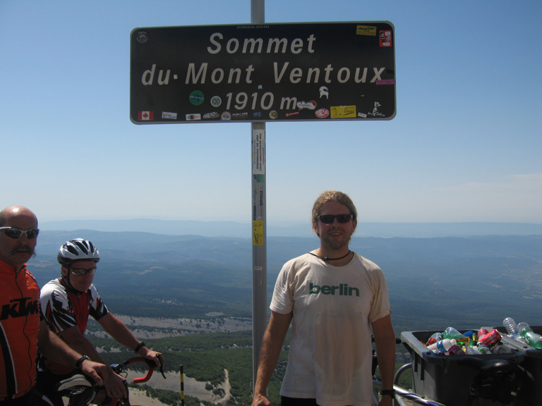
few minutes while loads of bikers (and the occassional runner) passed me. Eventually, however, I took the last turn at the last switchback and at about 12 noon stood on the summit of the Mont Ventoux. Well, it wasn't quite the summit yet. That I would do with Bernard some minutes later,
but at least I was at a parking area where I was surrounded by what seemed like 100s of people and as many cars. Big traffic jam at the summit and I was glad to be on my bike. I got off the bike, had someone take my summit photo and looked around.
It was a beautiful day and the mountain did not live up to its reputation, because it was not windy at all. Only the many people took away some of the elation I feld of being at the summit and having completed another of the French departmental highpoints, this time of the Vaucluse. Only 80somthing to go.
Bernard reached the summit about 20 minutes after me, but was in an equally good moood as me. We congratulated ourselves and then went up to the real high point another 10meters above the parking area to take a few more summit shots.
Eventually it was time to go down and we got on our bikes to ride back down to the Chalet Reynard, six kilometers away, without pedalling once. That was awesome, only the switchbacks, the cars and other riders slowed me down, but I still managed to get up to 55 km/h on the descend.
At the Chaley Reynard we took a 45 minutes pasta lunch, before taking of again for the long ride home. We acutally decided to go down a different route than the one we had come up because of a tempting 30km descend that awaited us on the other route.
Sure enought it was great fun and we did the 30km in maybe 35 minutes or so. My top speak was 63km, but I stayed often above 50km/h for long stretches.
Then over the next 2-3 hours or so, we biked through a fairly flat, but also very busy, section of the Vaucluse, with the temperature consistently being above 30 degrees. I was getting really tired and my butt was hurting and I wanted it to end.
Eventually after 143 kms and about 9 hours after setting out I reached the house again. Quite the adventure, almost like a real day on the Tour de France with a mountain of the highest category.
I had left Bernard 8kms away in a cafe, where I thought it may be more fun drinking a few beers than continuing the ordeal. Quite reasonable, but I still did not want to have to call Catherine and tell her that she should come pick us up, even though we were less than 10km away. Therefore, I fought my way up the hill to the house and then returned with the car to pick up Bernard.
The rest of the day I spent in or near the pool.
More Mountain Stuff: Back to Overview.
This page was last updated: Sep 2 2009